
Obrigado por apoiar este site ❤️
Faça uma doação
Faça uma doação
Mapa topográfico Blease Fell
Clique no mapa para exibir a altitude.
Obrigado por apoiar este site ❤️
Faça uma doação
Faça uma doação
Blease Fell
The Northern Fells make up a roughly circular upland area about 10 miles (16 km) wide. At the centre is the marshy depression of Skiddaw Forest — a treeless plateau at an altitude of 1,300 ft (400 m) — and flowing outward from here are the rivers which divide the area into three sectors. Between the Glenderaterra Beck and the River Caldew, the southeastern sector contains Blencathra and its satellites.
Obrigado por apoiar este site ❤️
Faça uma doação
Faça uma doação
Sobre este mapa
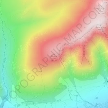
Nome: Mapa topográfico Blease Fell, altitude, relevo.
Altitude média: 482 m
Altitude mínima: 149 m
Altitude máxima: 854 m
Obrigado por apoiar este site ❤️
Faça uma doação
Faça uma doação
Outros mapas topográficos
Clique em um mapa para visualizar sua topografia, sua altitude e seu relevo.
River Glenderamackin
United Kingdom > England > Westmorland and Furness > Threlkeld
Altitude média: 346 m