
Mapa topográfico Pfaffenried
Mapa interativo
Clique no mapa para exibir a altitude.
Sobre este mapa
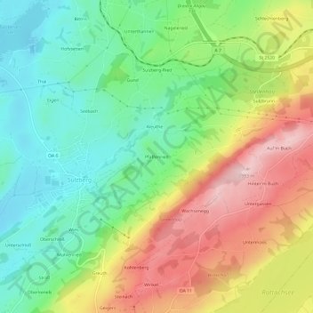
Nome: Mapa topográfico Pfaffenried, altitude, relevo.
Altitude média: 810 m
Altitude mínima: 696 m
Altitude máxima: 974 m
Outros mapas topográficos
Clique em um mapa para visualizar sua topografia, sua altitude e seu relevo.
Sulzberger See
Deutschland > Bayern > Landkreis Oberallgäu > Sulzberg > Thal
Sulzberger See, Thal, Sulzberg, Landkreis Oberallgäu, Bayern, 87477, Deutschland
Altitude média: 717 m