
Mapa topográfico Bajardo
Mapa interativo
Clique no mapa para exibir a altitude.
Bajardo
Its principal settlement, Bajardo itself, is a medieval village which stands at an elevation of 900 metres (3,000 ft) on a peak at the head of the basin of the Nervia torrent.
Sobre este mapa
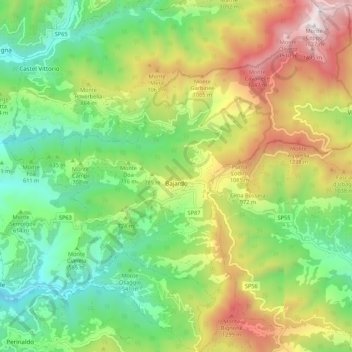
Nome: Mapa topográfico Bajardo, altitude, relevo.
Local: Bajardo, Provincia di Imperia, Liguria, 18031, Italy (43.86526 7.68489 43.94367 7.77718)
Altitude média: 710 m
Altitude mínima: 161 m
Altitude máxima: 1.610 m
Outros mapas topográficos
Clique em um mapa para visualizar sua topografia, sua altitude e seu relevo.