
Mapa topográfico Paulton
Clique no mapa para exibir a altitude.
Sobre este mapa
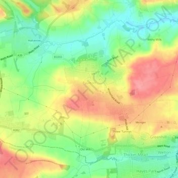
Nome: Mapa topográfico Paulton, altitude, relevo.
Altitude média: 115 m
Altitude mínima: 72 m
Altitude máxima: 162 m
Outros mapas topográficos
Clique em um mapa para visualizar sua topografia, sua altitude e seu relevo.
Bathwick Hill
United Kingdom > England > Bath and North East Somerset > Bath
Number 1 (Bathwick Lodge) is a 2-storey villa with a steep Mansard room, built in 1825, extended in 1840 and the late C19. Probably by John Pinch the Elder.[4] Number 2 is from the early 19th century and has shutters over the windows.[11] Number 3 includes a porch which is elaborately enriched with carving,…
Altitude média: 93 m
Hallatrow
United Kingdom > England > Bath and North East Somerset > High Littleton
Altitude média: 119 m
Norton Hawkfield
United Kingdom > England > Bath and North East Somerset > Norton Malreward
Altitude média: 96 m
Little Solsbury Hill
United Kingdom > England > Bath and North East Somerset > Batheaston
Altitude média: 88 m
Monger
United Kingdom > England > Bath and North East Somerset > Midsomer Norton
Altitude média: 118 m
Park Corner
United Kingdom > England > Bath and North East Somerset > Freshford > Park Corner
Altitude média: 93 m
Chewton Keynsham
United Kingdom > England > Bath and North East Somerset > Compton Dando
Altitude média: 57 m
Carlingcott
United Kingdom > England > Bath and North East Somerset > Peasedown St. John
Altitude média: 123 m
Pipehouse
United Kingdom > England > Bath and North East Somerset > Hinton Charterhouse
Altitude média: 94 m
Keynsham Memorial Park
United Kingdom > England > Bath and North East Somerset > Keynsham
Altitude média: 29 m
Stoney Littleton
United Kingdom > England > Bath and North East Somerset > Shoscombe
Altitude média: 116 m
Clutton Hill
United Kingdom > England > Bath and North East Somerset > Farmborough
Altitude média: 133 m
Maes Knoll
United Kingdom > England > Bath and North East Somerset > Norton Malreward
Altitude média: 110 m
Wick Green
United Kingdom > England > Bath and North East Somerset > Bishop Sutton
Altitude média: 82 m
Monger
United Kingdom > England > Bath and North East Somerset > Midsomer Norton
Altitude média: 118 m