
Obrigado por apoiar este site ❤️
Faça uma doação
Faça uma doação
Mapa topográfico Pocdol Mountains
Clique no mapa para exibir a altitude.
Obrigado por apoiar este site ❤️
Faça uma doação
Faça uma doação
Pocdol Mountains
The Pocdol Mountains form part of the boundary between the provinces of Albay and Sorsogon, in Region V, on the island of Luzon, in the Philippines. The group is located south-east of Mayon Volcano, between Albay Gulf and Sorsogon Bay, at 13°3'0"N, 123°57'30"E. The mountains have a triangular footprint of about 225 km2 (87 sq mi). There are several peaks above 1,000 m in elevation. The highest point is reported to be 1,102 m (3,615 ft) above sea level.
Obrigado por apoiar este site ❤️
Faça uma doação
Faça uma doação
Sobre este mapa
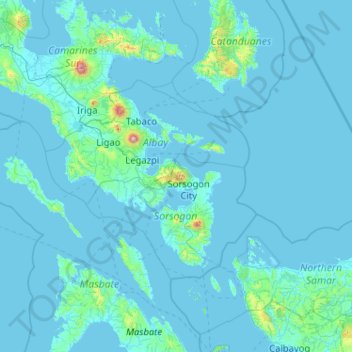
Nome: Mapa topográfico Pocdol Mountains, altitude, relevo.
Altitude média: 46 m
Altitude mínima: -2 m
Altitude máxima: 2.259 m
Obrigado por apoiar este site ❤️
Faça uma doação
Faça uma doação
Outros mapas topográficos
Clique em um mapa para visualizar sua topografia, sua altitude e seu relevo.