
Obrigado por apoiar este site ❤️
Faça uma doação
Faça uma doação
Mapa topográfico Paddy Freeman's Park
Clique no mapa para exibir a altitude.
Obrigado por apoiar este site ❤️
Faça uma doação
Faça uma doação
Sobre este mapa
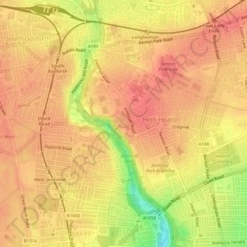
Nome: Mapa topográfico Paddy Freeman's Park, altitude, relevo.
Altitude média: 58 m
Altitude mínima: 13 m
Altitude máxima: 75 m
Obrigado por apoiar este site ❤️
Faça uma doação
Faça uma doação
Outros mapas topográficos
Clique em um mapa para visualizar sua topografia, sua altitude e seu relevo.
Obrigado por apoiar este site ❤️
Faça uma doação
Faça uma doação
Newburn
United Kingdom > England > Newcastle upon Tyne
In 1855, William Whellan's History, Topography, and Directory of Northumberland described the banks of the Tyne at this point having extensive iron works, coal staithes, brickyards, chemical works and other manufactories.
Altitude média: 58 m
Middle Brunton
United Kingdom > England > Newcastle upon Tyne > Hazlerigg Village
Altitude média: 63 m
Obrigado por apoiar este site ❤️
Faça uma doação
Faça uma doação