
Mapa topográfico Wroughton
Clique no mapa para exibir a altitude.
Sobre este mapa
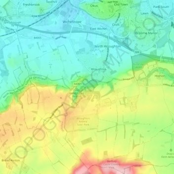
Nome: Mapa topográfico Wroughton, altitude, relevo.
Local: Wroughton, Swindon, England, United Kingdom (51.48246 -1.84692 51.55323 -1.76425)
Altitude média: 153 m
Altitude mínima: 95 m
Altitude máxima: 269 m
Outros mapas topográficos
Clique em um mapa para visualizar sua topografia, sua altitude e seu relevo.
Swindon
United Kingdom > England > Swindon
Swindon has an oceanic climate (Cfb in the Köppen climate classification), like the vast majority of the British Isles, with cool winters and warm summers. The nearest official weather station is RAF Lyneham, about 10 miles (16 km) west southwest of Swindon town centre. The weather station's elevation is 145…
Altitude média: 108 m