
Mapa topográfico Schnecksville
Mapa interativo
Clique no mapa para exibir a altitude.
Schnecksville
According to the U.S. Census Bureau, Schnecksville has a total area of 2.7 square miles (7.0 km2), of which 0.01 square miles (0.02 km2), or 0.28%, are water. Schnecksville sits on a ridge at an elevation of about 660 feet (200 m) above sea level. To the west, water flows to Jordan Creek, while to the east water flows to Coplay Creek. Both creeks are southeast-flowing tributaries of the Lehigh River and part of the Delaware River watershed.
Sobre este mapa
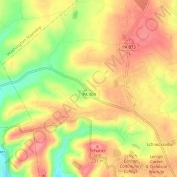
Nome: Mapa topográfico Schnecksville, altitude, relevo.
Altitude média: 197 m
Altitude mínima: 144 m
Altitude máxima: 229 m
Outros mapas topográficos
Clique em um mapa para visualizar sua topografia, sua altitude e seu relevo.
Orefield
United States > Pennsylvania > Lehigh County > North Whitehall Township
Altitude média: 141 m