
Faça uma doação
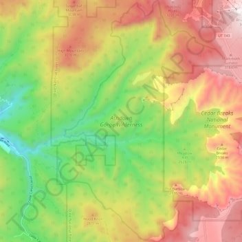
Mapa topográfico Ashdown Gorge Wilderness
Clique no mapa para exibir a altitude.
Faça uma doação
Ashdown Gorge Wilderness
The wilderness is within the Dixie National Forest adjacent to Cedar Breaks National Monument and characterized by extremely steep-walled canyons cut through the west rim of the Markagunt Plateau. Elevations in the wilderness range from 10,500 feet (3,200 m) to 7,500 feet (2,300 m). Rattlesnake Creek and Ashdown Creek flow through the wilderness. The 7,043 acres (28.5 km2) wilderness area was designated by the U.S. Congress in 1984 and is administered is by the United States Forest Service.
Faça uma doação
Sobre este mapa
Nome: Mapa topográfico Ashdown Gorge Wilderness, altitude, relevo.
Local: Ashdown Gorge Wilderness, Iron County, Utah, United States (37.59708 -112.91987 37.68692 -112.84080)
Altitude média: 2.715 m
Altitude mínima: 2.132 m
Altitude máxima: 3.344 m
Faça uma doação
Outros mapas topográficos
Clique em um mapa para visualizar sua topografia, sua altitude e seu relevo.