
Faça uma doação
Mapa topográfico Laguna Beach
Clique no mapa para exibir a altitude.
Faça uma doação
Laguna Beach
The land in and around Laguna Beach rises quickly from the shoreline into the hills and canyons of the San Joaquin Hills. The town's highest point, at an elevation of 1,007 feet (307 m), is Temple Hill in the Top of the World neighborhood. Because of its hilly topography and surrounding parklands, few roads run into or out of town; only the Coast Highway connecting to Newport Beach to the northwest and to Dana Point to the south, and State Route 133 crossing the hills in a northeastern direction through Laguna Canyon. Parts of Laguna Beach border the Aliso/Wood Canyons Regional Park.
Faça uma doação
Sobre este mapa
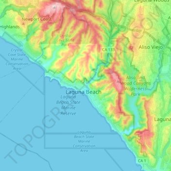
Nome: Mapa topográfico Laguna Beach, altitude, relevo.
Local: Laguna Beach, Orange County, California, United States (33.44274 -117.86456 33.61030 -117.73118)
Altitude média: 62 m
Altitude mínima: -1 m
Altitude máxima: 353 m
Faça uma doação
Outros mapas topográficos
Clique em um mapa para visualizar sua topografia, sua altitude e seu relevo.
Faça uma doação
Faça uma doação
Faça uma doação
Newport Beach
United States > California > Orange County > Newport Beach > Newport Beach
Newport Beach extends in elevation from sea level to the 1,161 ft (354 m) summit of Signal Peak in the San Joaquin Hills, but the official elevation is 25 ft (7.6 m) above sea level at a location of 33°37′0″N 117°53′51″W / 33.61667°N 117.89750°W / 33.61667; -117.89750 (33.616671, −117.897604).
Altitude média: 9 m
Faça uma doação
Faça uma doação
Faça uma doação
Faça uma doação
Faça uma doação
Faça uma doação
Faça uma doação