
Mapa topográfico Rotwand
Mapa interativo
Clique no mapa para exibir a altitude.
Sobre este mapa
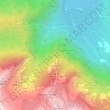
Nome: Mapa topográfico Rotwand, altitude, relevo.
Local: Rotwand, Ebensee am Traunsee, Bezirk Gmunden, 4802, Österreich (47.73892 13.82943 47.73902 13.82953)
Altitude média: 1.166 m
Altitude mínima: 643 m
Altitude máxima: 1.857 m
Outros mapas topográficos
Clique em um mapa para visualizar sua topografia, sua altitude e seu relevo.
Unterlangbath
Österreich > Bezirk Gmunden > Ebensee am Traunsee
Unterlangbath, Ebensee am Traunsee, Bezirk Gmunden, 4802, Österreich
Altitude média: 808 m