
Faça uma doação
Mapa topográfico Girardot
Clique no mapa para exibir a altitude.
Faça uma doação
Girardot
The municipality lies on a plain, framed by the foothills of the Cordillera Oriental, without notable topographic features, with some areas of difficult access in the mountainous area on the border with Nariño called Alonso Vera cordillera.
Faça uma doação
Sobre este mapa
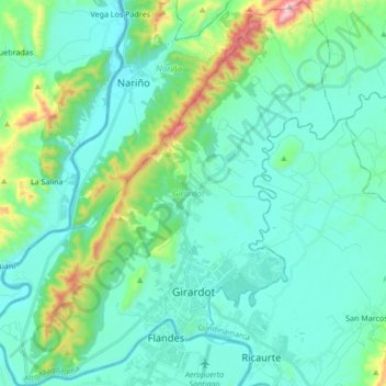
Nome: Mapa topográfico Girardot, altitude, relevo.
Local: Girardot, Alto Magdalena, Cundinamarca, Colombia (4.26535 -74.89052 4.43424 -74.73911)
Altitude média: 358 m
Altitude mínima: 232 m
Altitude máxima: 935 m
Faça uma doação
Outros mapas topográficos
Clique em um mapa para visualizar sua topografia, sua altitude e seu relevo.
Faça uma doação
Centro Experimental Gaviotas
Gaviotas has leveraged many forms of solar energy. They developed solar heating panels to provide hot water, which were installed in Gaviotas homes and housing developments in Medellín. The original design was not suited for Bogotá, however, since at 2,600 meters of altitude (9,000 ft) the city has a cooler…
Altitude média: 176 m
Faça uma doação
Floridablanca
Colombia > Santander > Floridablanca > Floridablanca
Floridablanca is situated at an altitude of about 925 metres (3,035 ft) in the Eastern Ranges of the Colombian Andes, though locally the topography varies greatly. To the east of the city the higher mountains of the Andes rise above the city, thrusted upwards by the north–south-trending Bucaramanga-Santa…
Altitude média: 1.091 m
Faça uma doação