
Obrigado por apoiar este site ❤️
Faça uma doação
Faça uma doação
Mapa topográfico Gasherbrum III
Clique no mapa para exibir a altitude.
Obrigado por apoiar este site ❤️
Faça uma doação
Faça uma doação
Sobre este mapa
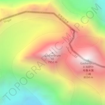
Nome: Mapa topográfico Gasherbrum III, altitude, relevo.
Altitude média: 7.082 m
Altitude mínima: 6.093 m
Altitude máxima: 7.992 m
Obrigado por apoiar este site ❤️
Faça uma doação
Faça uma doação
Outros mapas topográficos
Clique em um mapa para visualizar sua topografia, sua altitude e seu relevo.
Biafo Glacier
Pakistan > Gilgit-Baltistan > Shigar District
Biafo Glacier converging at Hispar La with 49 kilometres (30 mi) long Hispar Glacier situated at an elevation of 5,128 metres (16,824 ft), forms the glacial system considered as the world's longest non-polar glacial system which spans an overall distance of around 120 kilometres (75 mi). This frozen pathway…
Altitude média: 4.618 m
Obrigado por apoiar este site ❤️
Faça uma doação
Faça uma doação