
Faça uma doação
Mapa topográfico Les Pas
Clique no mapa para exibir a altitude.
Faça uma doação
Sobre este mapa
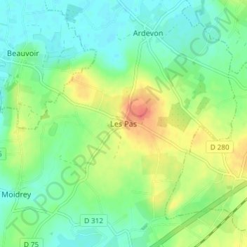
Nome: Mapa topográfico Les Pas, altitude, relevo.
Altitude média: 21 m
Altitude mínima: 3 m
Altitude máxima: 52 m
Faça uma doação
Outros mapas topográficos
Clique em um mapa para visualizar sua topografia, sua altitude e seu relevo.
Villedieu-les-Poêles
France > Normandy > Manche > Villedieu-les-Poêles-Rouffigny
Altitude média: 161 m
Faça uma doação
Faça uma doação
Saint-Lô
The square of the town hall was completely redeveloped in the 1990s. The city organised a large demonstration on the occasion of the fiftieth anniversary of the Normandy landings. The edges of the Vire were reconfigured with the rehabilitation of the towpath and the creation of a green beach, at the Place du…
Altitude média: 68 m
Faça uma doação
Faça uma doação
Faça uma doação
Faça uma doação
Faça uma doação
Faça uma doação
Faça uma doação
Faça uma doação
Faça uma doação
Faça uma doação
Faça uma doação
Faça uma doação
Faça uma doação
Faça uma doação
Faça uma doação
Saint-Lô
The square of the town hall was completely redeveloped in the 1990s. The city organised a large demonstration on the occasion of the fiftieth anniversary of the Normandy landings. The edges of the Vire were reconfigured with the rehabilitation of the towpath and the creation of a green beach, at the Place du…
Altitude média: 68 m
Faça uma doação
Faça uma doação