
Mapa topográfico Mount David
Mapa interativo
Clique no mapa para exibir a altitude.
Sobre este mapa
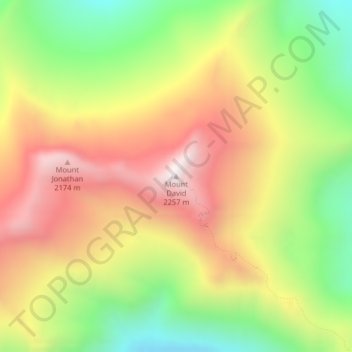
Nome: Mapa topográfico Mount David, altitude, relevo.
Local: Mount David, Chelan County, Washington, United States (47.96284 -120.98987 47.96294 -120.98977)
Altitude média: 1.736 m
Altitude mínima: 1.247 m
Altitude máxima: 2.224 m
Mount David is a prominent 7,420-foot (2,260-metre) mountain summit located in Chelan County of Washington state. The mountain is situated in the Glacier Peak Wilderness, on land managed by the Okanogan-Wenatchee National Forest. Mount David is the highest point of Wenatchee Ridge, a subrange which also includes Indian Head Peak, Whittier Peak, Mount Saul, and Mount Jonathan. Its nearest higher neighbor is Bandit Peak, 5.69 mi (9.16 km) to the east-northeast. Precipitation runoff from Mount David drains into tributaries of the White River. Although modest in elevation, relief is significant since Mt. David rises 5,100 feet above the White River Valley in two miles. This peak was named for the biblical David by Albert Hale Sylvester, a pioneer surveyor, explorer, topographer, and forest supervisor in the Cascades who named thousands of natural features. This mountain can be climbed via the strenuous seven-mile Mount David Trail with over 5,000 feet of elevation gain.
Outros mapas topográficos
Clique em um mapa para visualizar sua topografia, sua altitude e seu relevo.
Sugarloaf Peak
United States > Washington > Chelan County
Sugarloaf Peak, Chelan County, Washington, United States
Altitude média: 1.550 m
Wenatchee
United States > Washington > Chelan County > Wenatchee
Wenatchee, Chelan County, Washington, 98801, United States
Altitude média: 302 m
Lake Julius
United States > Washington > Chelan County
Lake Julius, Chelan County, Washington, United States
Altitude média: 1.697 m
Cashmere
United States > Washington > Chelan County > Cashmere
Cashmere, Chelan County, Washington, United States
Altitude média: 298 m