
Faça uma doação
Mapa topográfico Mount Washburn
Clique no mapa para exibir a altitude.
Faça uma doação
Mount Washburn
Mount Washburn, elevation 10,219 feet (3,115 m), is a prominent mountain peak in the Washburn Range in Yellowstone National Park, Wyoming. The peak was named in 1870 to honor Henry D. Washburn, leader of the Washburn–Langford–Doane Expedition. The Washburn Range is one of two mountains ranges completely within the boundaries of Yellowstone.
Faça uma doação
Sobre este mapa
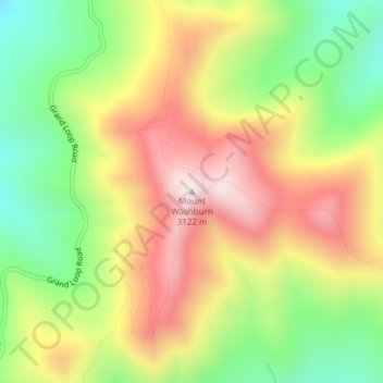
Nome: Mapa topográfico Mount Washburn, altitude, relevo.
Local: Mount Washburn, Park County, Wyoming, United States (44.79751 -110.43384 44.79761 -110.43374)
Altitude média: 2.798 m
Altitude mínima: 2.503 m
Altitude máxima: 3.109 m
Faça uma doação
Outros mapas topográficos
Clique em um mapa para visualizar sua topografia, sua altitude e seu relevo.
Cody
United States > Wyoming > Park County
Cody's elevation is approximately 5016 ft (1,500 m) above sea level. The main part of the city is split across three levels, separated by about 60 feet (18 m).
Altitude média: 1.557 m
Cody
United States > Wyoming > Park County
Cody's elevation is approximately 5016 ft (1,500 m) above sea level. The main part of the city is split across three levels, separated by about 60 feet (18 m).
Altitude média: 1.557 m
Faça uma doação
Cody
United States > Wyoming > Park County
Cody's elevation is approximately 4,997 feet (1,523 m) above sea level. The main part of the city is split across three levels, separated by about 60 feet (18 m).
Altitude média: 1.557 m