
Mapa topográfico Wingerworth
Clique no mapa para exibir a altitude.
Sobre este mapa
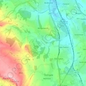
Nome: Mapa topográfico Wingerworth, altitude, relevo.
Altitude média: 149 m
Altitude mínima: 76 m
Altitude máxima: 299 m
Outros mapas topográficos
Clique em um mapa para visualizar sua topografia, sua altitude e seu relevo.
Lightwood
United Kingdom > England > Derbyshire > North East Derbyshire > Eckington
Altitude média: 168 m
Ogston Reservoir
United Kingdom > England > Derbyshire > North East Derbyshire > Woolley Moor
Altitude média: 137 m
Doghole Wood
United Kingdom > England > Derbyshire > North East Derbyshire > Holymoorside
Altitude média: 142 m
Dronfield Nature Park
United Kingdom > England > Derbyshire > North East Derbyshire > Dronfield > Unstone Green
Altitude média: 156 m
Holestone Moor
United Kingdom > England > Derbyshire > North East Derbyshire > Ashover CP
Altitude média: 231 m
Norwood Cottage Lakes
United Kingdom > England > Derbyshire > North East Derbyshire > Killamarsh
Altitude média: 93 m
Highlane
United Kingdom > England > Derbyshire > North East Derbyshire > Eckington > Ridgeway
Altitude média: 130 m
Grassmoor Country Park
United Kingdom > England > Derbyshire > North East Derbyshire > Corbriggs
Altitude média: 116 m
Millthorpe
United Kingdom > England > Derbyshire > North East Derbyshire > Holmesfield > Millthorpe
Altitude média: 211 m
Troway
United Kingdom > England > Derbyshire > North East Derbyshire > Eckington > Troway
Altitude média: 157 m
Cartledge
United Kingdom > England > Derbyshire > North East Derbyshire > Holmesfield > Cartledge
Altitude média: 192 m