
Mapa topográfico Woodbridge
Clique no mapa para exibir a altitude.
Woodbridge
The Suffolk Travler suggests a similar origin to The Dictionary but originating from a bridge over a hollow way that leads from Woodbridge Market Place to the Ipswich. But this is disputed by Rev. Thomas Carthew, then perpetual curate of Woodrbidge who points out that the bridge had existed for less than a hundred years at that point and therefore was not old enough to be the source of the name. He instead suggests Oden or Woden (Odin) and Burgh, Bury, or Brigg (town). The Topographical Dictionary of England suggests a combination of Woden and Bryge.
Sobre este mapa
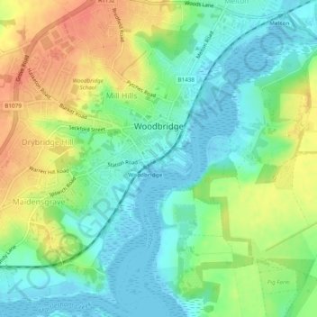
Nome: Mapa topográfico Woodbridge, altitude, relevo.
Local: Woodbridge, East Suffolk, Suffolk, England, United Kingdom (52.07639 1.28439 52.10577 1.32901)
Altitude média: 19 m
Altitude mínima: -5 m
Altitude máxima: 46 m
Outros mapas topográficos
Clique em um mapa para visualizar sua topografia, sua altitude e seu relevo.
Gunton Sands
United Kingdom > England > Suffolk > East Suffolk > Lowestoft > Corton
Altitude média: 10 m
Sutton Hoo Archeological Site
United Kingdom > England > Suffolk > East Suffolk > Sutton
Altitude média: 19 m
Lowestoft Inner Harbour
United Kingdom > England > Suffolk > East Suffolk > Lowestoft > Oulton Broad
Altitude média: 8 m
Site of old Orfordness Lighthouse
United Kingdom > England > Suffolk > East Suffolk > Orford
Altitude média: 0 m
Rendlesham UFO Landing Site #2
United Kingdom > England > Suffolk > East Suffolk > Butley Abbey
Altitude média: 14 m