
Mapa topográfico Unkelbach
Mapa interativo
Clique no mapa para exibir a altitude.
Sobre este mapa
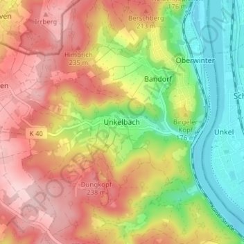
Nome: Mapa topográfico Unkelbach, altitude, relevo.
Altitude média: 154 m
Altitude mínima: 49 m
Altitude máxima: 252 m
Outros mapas topográficos
Clique em um mapa para visualizar sua topografia, sua altitude e seu relevo.
Kripp
Deutschland > Rheinland-Pfalz > Landkreis Ahrweiler > Remagen
Kripp, Remagen, Landkreis Ahrweiler, Rheinland-Pfalz, Deutschland
Altitude média: 75 m
Rolandswerth
Deutschland > Rheinland-Pfalz > Landkreis Ahrweiler > Remagen
Rolandswerth, Remagen, Landkreis Ahrweiler, Rheinland-Pfalz, 53179, Deutschland
Altitude média: 106 m
Oberwinter
Deutschland > Rheinland-Pfalz > Landkreis Ahrweiler > Remagen > Oberwinter
Oberwinter, Remagen, Landkreis Ahrweiler, Rheinland-Pfalz, 53572, Deutschland
Altitude média: 120 m
Dungkopfsee
Deutschland > Rheinland-Pfalz > Landkreis Ahrweiler > Remagen > Unkelbach
Dungkopfsee, Unkelbach, Remagen, Landkreis Ahrweiler, Rheinland-Pfalz, 53424, Deutschland
Altitude média: 177 m
Bandorf
Deutschland > Rheinland-Pfalz > Landkreis Ahrweiler > Remagen > Bandorf
Bandorf, Remagen, Landkreis Ahrweiler, Rheinland-Pfalz, 53572, Deutschland
Altitude média: 131 m
Kripp
Deutschland > Rheinland-Pfalz > Landkreis Ahrweiler > Remagen > Kripp
Kripp, Remagen, Landkreis Ahrweiler, Rheinland-Pfalz, 53545, Deutschland
Altitude média: 88 m