
Obrigado por apoiar este site ❤️
Faça uma doação
Faça uma doação
Mapa topográfico Glenridding Dodd
Clique no mapa para exibir a altitude.
Obrigado por apoiar este site ❤️
Faça uma doação
Faça uma doação
Glenridding Dodd
Glenridding Dodd (the rounded hill above Glenridding) is a small fell in the English Lake District, at the end of a ridge descending from the Helvellyn range in the Eastern Fells. It stands above the village of Glenridding and on the western shore of Ullswater. Although small and not of great elevation, its top is a fine viewpoint for Ullswater and for the fells clustered round the valleys above Patterdale.
Obrigado por apoiar este site ❤️
Faça uma doação
Faça uma doação
Sobre este mapa
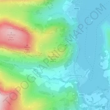
Nome: Mapa topográfico Glenridding Dodd, altitude, relevo.
Altitude média: 298 m
Altitude mínima: 143 m
Altitude máxima: 698 m
Obrigado por apoiar este site ❤️
Faça uma doação
Faça uma doação