
Faça uma doação
Mapa topográfico Old Stone Fort State Archaeological Park
Clique no mapa para exibir a altitude.
Faça uma doação
Old Stone Fort State Archaeological Park
The Duck River system spills over a limestone-rich shelf of the western Cumberland Plateau known as the Highland Rim. As the Duck and Little Duck approach their convergence, they rapidly drop in elevation, and have cut relatively deep gorges around the peninsula upon which the ancient structure is located. Both gorges are highlighted by a series of substantial waterfalls and whitewater rapids. The natural waterpower in these two gorges attracted entrepreneurs and millwrights throughout the 19th century.
Faça uma doação
Sobre este mapa
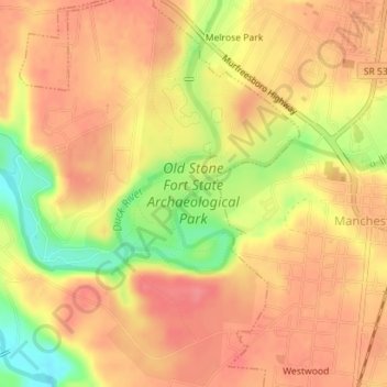
Nome: Mapa topográfico Old Stone Fort State Archaeological Park, altitude, relevo.
Altitude média: 316 m
Altitude mínima: 268 m
Altitude máxima: 339 m
Faça uma doação
Outros mapas topográficos
Clique em um mapa para visualizar sua topografia, sua altitude e seu relevo.