
Faça uma doação
Mapa topográfico Lee Vining
Clique no mapa para exibir a altitude.
Faça uma doação
Lee Vining
Lee Vining (formerly Leevining, Poverty Flat, and Lakeview) is an unincorporated community and census-designated place (CDP) in Mono County, California, United States. It is located 25 miles (40 km) south-southeast of Bridgeport, at an elevation of 6,781 feet (2,067 m). Lee Vining is located on the southwest shore of Mono Lake. The population was 217 as of the 2020 census.
Faça uma doação
Sobre este mapa
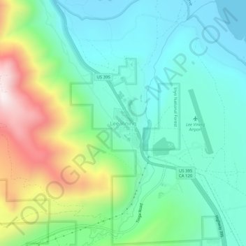
Nome: Mapa topográfico Lee Vining, altitude, relevo.
Local: Lee Vining, Mono County, California, 93541, United States (37.93743 -119.14182 37.97743 -119.10182)
Altitude média: 2.180 m
Altitude mínima: 1.945 m
Altitude máxima: 2.768 m
Faça uma doação
Outros mapas topográficos
Clique em um mapa para visualizar sua topografia, sua altitude e seu relevo.
Mono Lake
United States > California > Mono County
Lake Russell was the prehistoric predecessor to Mono Lake, during the Pleistocene. Its shoreline reached the modern-day elevation of 7,480 feet (2,280 m), about 1,100 feet (330 m) higher than the present-day lake. As of 1.6 million years ago, Lake Russell discharged to the northeast, into the Walker River…
Altitude média: 2.008 m
Faça uma doação
Faça uma doação