
Mapa topográfico Bondend
Clique no mapa para exibir a altitude.
Sobre este mapa
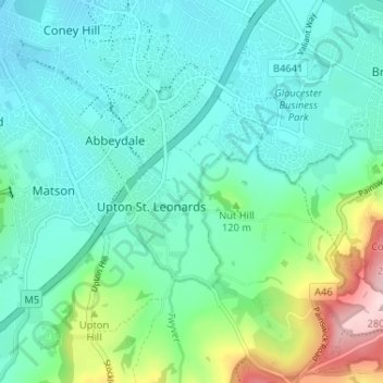
Nome: Mapa topográfico Bondend, altitude, relevo.
Altitude média: 82 m
Altitude mínima: 26 m
Altitude máxima: 283 m
Outros mapas topográficos
Clique em um mapa para visualizar sua topografia, sua altitude e seu relevo.
Jubilee Playing Field & Athletics Track
United Kingdom > England > Gloucestershire > Stroud > Cam > Draycott
Altitude média: 45 m
Rodborough Common
United Kingdom > England > Gloucestershire > Stroud > Lightpill
Altitude média: 114 m
Gloucester and Sharpness Canal
United Kingdom > England > Gloucestershire > Stroud
Altitude média: 34 m
River Frome
United Kingdom > England > Gloucestershire > Stroud > Chalford > Chalford Hill
Altitude média: 163 m
Alderley
United Kingdom > England > Gloucestershire > Stroud
In A Topographical Dictionary of England by Samuel Lewis published in 1831, Alderley is described thus.
Altitude média: 95 m