
Faça uma doação
Mapa topográfico Houston
Clique no mapa para exibir a altitude.
Faça uma doação
Houston
The Houston Hikers' Society provides website where trail information, maps, photos and driving directions can be accessed. The Morice Mountain Nordic Ski Club is a volunteer non-profit society. The MMNSC is responsible for all developments and trail grooming as well as maintenance of the facilities, and for trail users' fee collections. The ski trails are situated 8 km (5 mi) south of Houston on Buck Flats Road. Skiing enthusiasts are able to explore over 45 km (28 mi) of challenging and beginner trails covering a rolling topography around Silverthorne Lake.
Faça uma doação
Sobre este mapa
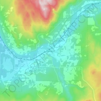
Nome: Mapa topográfico Houston, altitude, relevo.
Altitude média: 728 m
Altitude mínima: 574 m
Altitude máxima: 1.235 m
Faça uma doação
Outros mapas topográficos
Clique em um mapa para visualizar sua topografia, sua altitude e seu relevo.
Donald Lake
Canada > British Columbia > Regional District of Bulkley-Nechako > Area C (Stuart Lake/Omineca Valley)
Altitude média: 808 m
Skeena Mountains
Canada > British Columbia > Regional District of Bulkley-Nechako > Area C (Stuart Lake/Omineca Valley)
Altitude média: 1.339 m
Silver Creek
Canada > British Columbia > Regional District of Bulkley-Nechako > Area C (Stuart Lake/Omineca Valley)
Altitude média: 1.005 m
Grassy Plains
Canada > British Columbia > Regional District of Bulkley-Nechako > Area E (Ootsa Lake/François Lake)
Altitude média: 911 m
Faça uma doação
Rose Lake
Canada > British Columbia > Regional District of Bulkley-Nechako > Area B (Broman Lake/Sheraton)
Altitude média: 775 m
Fort Fraser
Canada > British Columbia > Regional District of Bulkley-Nechako > Area D (Endako/Fort Fraser)
Altitude média: 732 m
Nechako Plateau
Canada > British Columbia > Regional District of Bulkley-Nechako > Area G (Morice Valley/Babine Valley)
Altitude média: 965 m
Mount Germansen
Canada > British Columbia > Regional District of Bulkley-Nechako > Area C (Stuart Lake/Omineca Valley)
Altitude média: 1.701 m
Faça uma doação
Mount Milligan
Canada > British Columbia > Regional District of Bulkley-Nechako > Area C (Stuart Lake/Omineca Valley)
Altitude média: 1.199 m
Mount Ogden
Canada > British Columbia > Regional District of Bulkley-Nechako > Area C (Stuart Lake/Omineca Valley)
Altitude média: 1.614 m
Bulkley Valley
Canada > British Columbia > Regional District of Bulkley-Nechako
Altitude média: 1.050 m
Emmett Lake
Canada > British Columbia > Regional District of Bulkley-Nechako > Area D (Endako/Fort Fraser)
Altitude média: 966 m
Faça uma doação
Smaby Peak
Canada > British Columbia > Regional District of Bulkley-Nechako > Area E (Ootsa Lake/François Lake)
Altitude média: 1.740 m
Smith Island
Canada > British Columbia > Regional District of Bulkley-Nechako > Area C (Stuart Lake/Omineca Valley)
Altitude média: 886 m
Fort Fraser
Canada > British Columbia > Regional District of Bulkley-Nechako > Area D (Endako/Fort Fraser)
Altitude média: 732 m
Old Fort
Canada > British Columbia > Regional District of Bulkley-Nechako > Area G (Morice Valley/Babine Valley)
Altitude média: 784 m
Faça uma doação
Omineca Mountains
Canada > British Columbia > Regional District of Bulkley-Nechako > Area C (Stuart Lake/Omineca Valley)
Altitude média: 919 m
Babine Range
Canada > British Columbia > Regional District of Bulkley-Nechako > Area A (Hudson Bay Mountain)
Altitude média: 1.893 m
St. Mary Lake
Canada > British Columbia > Regional District of Bulkley-Nechako > Area C (Stuart Lake/Omineca Valley)
Altitude média: 807 m
Smoke Mountain
Canada > British Columbia > Regional District of Bulkley-Nechako > Area E (Ootsa Lake/François Lake)
Altitude média: 1.475 m
Faça uma doação