
Mapa topográfico La Spezia
Mapa interativo
Clique no mapa para exibir a altitude.
Sobre este mapa
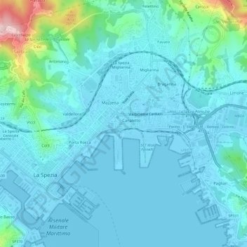
Nome: Mapa topográfico La Spezia, altitude, relevo.
Local: La Spezia, Follo, La Spezia, Liguria, Italy (44.09906 9.79646 44.12501 9.85458)
Altitude média: 35 m
Altitude mínima: -3 m
Altitude máxima: 274 m
Because of its topography, the city is not exposed to winds from the north, which lap western Liguria, but to those from the southeast. These may bring heavy rain and they can reach 80 kilometres per hour (50 mph), in rare cases causing the blocking of the port. The only northern wind reaching the city is the north-eastern Grecale, common during incursions of Arctic air, when the cold air flowing over the warmer Tyrrhenian sea triggers the formation of low pressures, draining the colder and heavier air trapped in the Po Valley, behind the Apennine Mountains.
Outros mapas topográficos
Clique em um mapa para visualizar sua topografia, sua altitude e seu relevo.
Cinque Terre
Italy > Liguria > La Spezia > Vernazza
Cinque Terre, Vernazza, Follo, La Spezia, Liguria, 19010, Italy
Altitude média: 221 m
Riomaggiore
Riomaggiore, La Spezia, Liguria, 19017, Italy
Altitude média: 250 m