
Obrigado por apoiar este site ❤️
Faça uma doação
Faça uma doação
Mapa topográfico Phakding
Clique no mapa para exibir a altitude.
Obrigado por apoiar este site ❤️
Faça uma doação
Faça uma doação
Phakding
Phakding is a small village in the Khumbu region of Nepal. It lies in the Dudh Kosi river valley just north of Lukla and south of Monjo, at an altitude of 2,610 m. It has been a UNESCO World Heritage Site since 1979. Phakding has a population of 550 locals, mostly Sherpa and Tamang. All of these people belong to Tibetan Buddhism and pray in a small Gompa at the centre of the village.
Obrigado por apoiar este site ❤️
Faça uma doação
Faça uma doação
Sobre este mapa
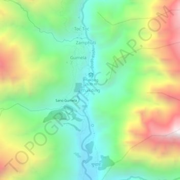
Nome: Mapa topográfico Phakding, altitude, relevo.
Local: Phakding, Khumbupasanglahmu, Solukhumbu, Koshi Province, Nepal (27.72013 86.69269 27.76013 86.73269)
Altitude média: 3.111 m
Altitude mínima: 2.503 m
Altitude máxima: 4.121 m
Obrigado por apoiar este site ❤️
Faça uma doação
Faça uma doação
Outros mapas topográficos
Clique em um mapa para visualizar sua topografia, sua altitude e seu relevo.