
Mapa topográfico Satara
Mapa interativo
Clique no mapa para exibir a altitude.
Sobre este mapa
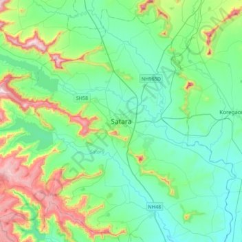
Nome: Mapa topográfico Satara, altitude, relevo.
Local: Satara, Maharashtra, 415002, India (17.52832 73.84417 17.84832 74.16417)
Altitude média: 748 m
Altitude mínima: 594 m
Altitude máxima: 1.250 m
Satara city has a tropical wet and dry climate (Köppen climate classification: Aw) that is influenced by the relatively high altitude and mountains surrounding the city. Summers are more hot than the winters. Satara city receives rainfall from 900 mm to 1,500 mm depending on the strength of the monsoon.
Outros mapas topográficos
Clique em um mapa para visualizar sua topografia, sua altitude e seu relevo.
Sajjangad
India > Maharashtra > Satara > New Banghar
Sajjangad, Thoseghar Road, New Banghar, Satara, Maharashtra, India
Altitude média: 747 m
Ajinkyatara Fort
India > Maharashtra > Satara > Satara
Ajinkyatara Fort, Ajinkyatara Paschim Darawaja (West Gate) Road, Satara, Maharashtra, 415002, India
Altitude média: 764 m
Urmodi River
India > Maharashtra > Satara > Satara
Urmodi River, Satara, Maharashtra, 415002, India
Altitude média: 696 m