
Obrigado por apoiar este site ❤️
Faça uma doação
Faça uma doação
Mapa topográfico John Gamble Park
Clique no mapa para exibir a altitude.
Obrigado por apoiar este site ❤️
Faça uma doação
Faça uma doação
Sobre este mapa
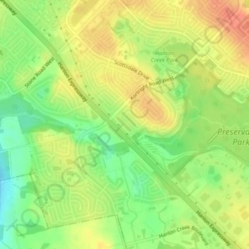
Nome: Mapa topográfico John Gamble Park, altitude, relevo.
Local: John Gamble Park, Hanlon Creek, Guelph, Ontario, Canada (43.50454 -80.23384 43.50709 -80.23042)
Altitude média: 327 m
Altitude mínima: 301 m
Altitude máxima: 347 m
Obrigado por apoiar este site ❤️
Faça uma doação
Faça uma doação
Outros mapas topográficos
Clique em um mapa para visualizar sua topografia, sua altitude e seu relevo.
Guelph
This region of Ontario has cold winters and warm, humid summers, falling into the Köppen climate classification Dfb zone, with moderately high rainfall and snowfall. It is generally a couple of degrees cooler than lower elevation regions on the Great Lakes shorelines, especially so in winter, the exception…
Altitude média: 344 m