
Faça uma doação
Mapa topográfico Tyree
Clique no mapa para exibir a altitude.
Faça uma doação
Sobre este mapa
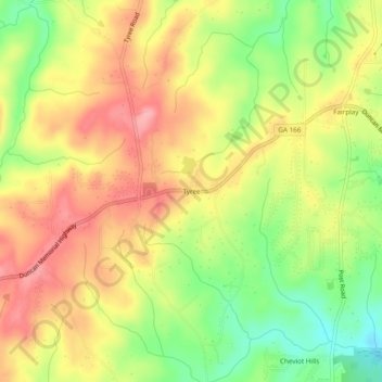
Nome: Mapa topográfico Tyree, altitude, relevo.
Local: Tyree, Douglas County, Georgia, United States (33.59511 -84.89938 33.63511 -84.85938)
Altitude média: 346 m
Altitude mínima: 284 m
Altitude máxima: 397 m
Faça uma doação
Outros mapas topográficos
Clique em um mapa para visualizar sua topografia, sua altitude e seu relevo.
Douglasville
United States > Georgia > Douglas County
Located along a natural rise in the topography, Douglasville was originally known as "Skint Chestnut." The name was derived from a large tree used by Native Americans as a landmark; it was stripped of its bark so as to be more conspicuous.
Altitude média: 310 m