
Mapa topográfico Montebelluna
Mapa interativo
Clique no mapa para exibir a altitude.
Sobre este mapa
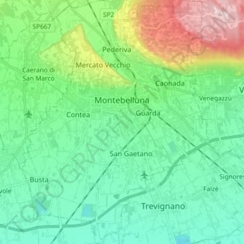
Nome: Mapa topográfico Montebelluna, altitude, relevo.
Local: Montebelluna, Treviso, Veneto, 31044, Italy (45.72298 11.99231 45.81314 12.09770)
Altitude média: 124 m
Altitude mínima: 40 m
Altitude máxima: 369 m
The territory of Montebelluna is largely flat, with altitudes ranging from 69 m a.s.l., found south of San Gaetano, to 144 m, north of Pederiva. The landscape is also characterized by the presence of two hills, including the western end of Montello (where the maximum altitude is, 343 m) and the more modest Capo di Monte (or Montebelluna Alta, or even the hill of Mercato Vecchio, 199 m). Between the two reliefs passes a natural corridor (along which the Feltrina passes), once the original bed of the Piave.
Outros mapas topográficos
Clique em um mapa para visualizar sua topografia, sua altitude e seu relevo.
Brioni
Italy > Veneto > Treviso > San Vito di Altivole
Brioni, San Vito di Altivole, Altivole, Fonte, Treviso, Veneto, 31039, Italy
Altitude média: 83 m
Casale sul Sile
Casale sul Sile, Treviso, Veneto, 31032, Italy
Altitude média: 6 m