
Faça uma doação
Mapa topográfico Drumclog
Clique no mapa para exibir a altitude.
Faça uma doação
Drumclog
Drumclog is a small village in South Lanarkshire, Parish of Avendale and Drumclog, Scotland. The settlement is situated on the A71, between Caldermill and Priestland in East Ayrshire at an elevation of 197 metres (646 feet) and about five miles (eight kilometres) west of Strathaven.
Faça uma doação
Sobre este mapa
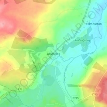
Nome: Mapa topográfico Drumclog, altitude, relevo.
Altitude média: 216 m
Altitude mínima: 178 m
Altitude máxima: 277 m
Faça uma doação
Outros mapas topográficos
Clique em um mapa para visualizar sua topografia, sua altitude e seu relevo.
Langlands Moss Lowland Raised Peatbog
United Kingdom > Scotland > South Lanarkshire > East Kilbride
Altitude média: 204 m
Clyde Valley Family Park's Island
United Kingdom > Scotland > South Lanarkshire > Hazelbank > Birkhill
Altitude média: 119 m
Craignethan Castle
United Kingdom > Scotland > South Lanarkshire > Crossford > Tillietudlem
Altitude média: 121 m
Langlands Moss Local Nature Reserve
United Kingdom > Scotland > South Lanarkshire > East Kilbride
Altitude média: 204 m
Faça uma doação
Trough Linn Woodlands Project
United Kingdom > Scotland > South Lanarkshire > East Kilbride
Altitude média: 185 m
Faça uma doação