
Faça uma doação
Mapa topográfico Isla Fernandina
Clique no mapa para exibir a altitude.
Faça uma doação
Sobre este mapa
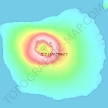
Nome: Mapa topográfico Isla Fernandina, altitude, relevo.
Local: Isla Fernandina, Cantón Isabela, Galápagos, Ecuador (-0.50703 -91.66144 -0.26025 -91.37671)
Altitude média: 201 m
Altitude mínima: 0 m
Altitude máxima: 1.478 m
Faça uma doação
Outros mapas topográficos
Clique em um mapa para visualizar sua topografia, sua altitude e seu relevo.
Wolf
Ecuador > Galápagos > Cantón Isabela
Wolf Island (Spanish: Isla Wolf) is a small island in the northern Galápagos Islands. It has an area of 1.3 km2 (0.5 sq mi) and a maximum altitude of 253 m (830 ft) above sea level. The island is remote from the main archipelago and has no permanent population. The Galápagos National Park does not allow…
Altitude média: 15 m
Roca Redonda
Ecuador > Galápagos > Cantón Isabela
Redonda Rock (Spanish: Roca Redonda, "Round Rock") is a flat-topped, steep-sided islet located roughly 25 km (16 mi) northwest of the island of Isabela in Ecuador's Galápagos Islands. Redonda measures 100 m (330 ft) long and 50 m (160 ft) wide with a maximum elevation of 67 m (220 ft). Its isolation and…
Altitude média: 0 m
Faça uma doação