
Obrigado por apoiar este site ❤️
Faça uma doação
Faça uma doação
Mapa topográfico Arnison Crag
Clique no mapa para exibir a altitude.
Obrigado por apoiar este site ❤️
Faça uma doação
Faça uma doação
Arnison Crag
Although properly a northeastern ridge of Birks and having little topographical prominence, Arnison Crag was classed as a separate fell by Alfred Wainwright in his Pictorial Guide to the Lakeland Fells. That convention is followed here. In support of his decision he referred to it as ‘a low hill with a summit worthy of a mountain’.
Obrigado por apoiar este site ❤️
Faça uma doação
Faça uma doação
Sobre este mapa
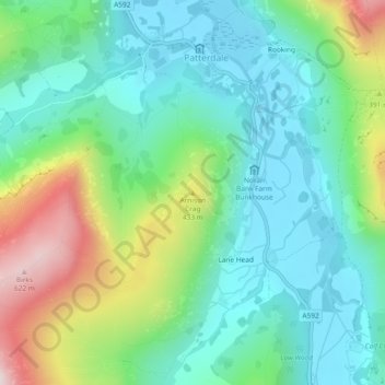
Nome: Mapa topográfico Arnison Crag, altitude, relevo.
Altitude média: 287 m
Altitude mínima: 147 m
Altitude máxima: 635 m
Obrigado por apoiar este site ❤️
Faça uma doação
Faça uma doação
Outros mapas topográficos
Clique em um mapa para visualizar sua topografia, sua altitude e seu relevo.
Brothers Water
United Kingdom > England > Westmorland and Furness > Patterdale > Hartsop
Altitude média: 298 m
Obrigado por apoiar este site ❤️
Faça uma doação
Faça uma doação