
Mapa topográfico Crowborough
Clique no mapa para exibir a altitude.
Crowborough
In the late 19th century, Crowborough was promoted as a health resort based on its high elevation, the rolling hills and surrounding forest. Estate agents even called it "Scotland in Sussex". The town's golf course opened in 1895, followed by a fire station and hospital in 1900.
Sobre este mapa
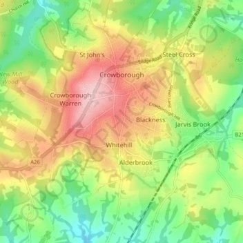
Nome: Mapa topográfico Crowborough, altitude, relevo.
Local: Crowborough, Wealden, East Sussex, England, United Kingdom (51.02955 0.11916 51.06922 0.19790)
Altitude média: 146 m
Altitude mínima: 64 m
Altitude máxima: 244 m
Outros mapas topográficos
Clique em um mapa para visualizar sua topografia, sua altitude e seu relevo.
Punnetts Town Recreation Ground
United Kingdom > England > East Sussex > Wealden > Punnett's Town > Chapel Cross
Altitude média: 125 m
Ashdown Forest
United Kingdom > England > East Sussex > Wealden
Ashdown Forest is an ancient area of open heathland occupying the highest sandy ridge-top of the High Weald Area of Outstanding Natural Beauty. It is situated 30 miles (48 km) south of London in the county East Sussex, England. Rising to an elevation of 732 feet (223 m) above sea level, its heights provide…
Altitude média: 117 m
Colemans Hatch
United Kingdom > England > East Sussex > Wealden > Upper Hartfield
Altitude média: 98 m
Broadwater Warren Nature Reserve
United Kingdom > England > East Sussex > Wealden > Groombridge
Altitude média: 84 m
Sheffield Green
United Kingdom > England > East Sussex > Wealden > Sheffield Park
Altitude média: 50 m
Best Beech Hill
United Kingdom > England > East Sussex > Wealden > Best Beech Hill
Altitude média: 120 m