
Mapa topográfico Beaufort
Clique no mapa para exibir a altitude.
Beaufort
Beaufort has an elevation-influenced oceanic climate (Köppen: Cfb), with tepid, relatively dry summers and cool, wetter winters. Average maxima vary from 25.3 °C (77.5 °F) in January to 10.1 °C (50.2 °F) in July, while average minima fluctuate between 11.5 °C (52.7 °F) in February and 3.2 °C (37.8 °F) in July. Mean average annual precipitation is moderately low 685.2 mm (26.98 in), but is frequent, spread between 167.1 precipitation days. Consequently, the town is not sunny, experiencing 180.2 cloudy days and only 55.2 clear days annually. Extreme temperatures have ranged from 44.1 °C (111.4 °F) on 7 February 2009 to −6.0 °C (21.2 °F) on 21 July 1982. All climate data was sourced from Ballarat Airport, located 37.2 kilometres (23.1 mi) southeast of Nhill at slightly higher elevation (435 metres (1,427 ft)).
Sobre este mapa
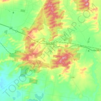
Nome: Mapa topográfico Beaufort, altitude, relevo.
Local: Beaufort, Shire of Pyrenees, Victoria, 3373, Australia (-37.49550 143.22918 -37.38531 143.43986)
Altitude média: 390 m
Altitude mínima: 323 m
Altitude máxima: 513 m
Outros mapas topográficos
Clique em um mapa para visualizar sua topografia, sua altitude e seu relevo.
Ballarat
Ballarat has a moderate oceanic climate (Köppen climate classification Cfb) with four distinct seasons. Its elevation, ranging between 400 and 630 metres (1,310 and 2,070 feet) above sea level, causes its mean monthly temperatures to tend to be on average 3 to 5 °C (5 to 9 °F) below those of Melbourne,…
Altitude média: 470 m
Melbourne
Melbourne is also prone to isolated convective showers forming when a cold pool crosses the state, especially if there is considerable daytime heating. These showers are often heavy and can include hail, squalls, and significant drops in temperature, but they often pass through very quickly with a rapid…
Altitude média: 49 m
Mount Bogong
The Big River separates the massif of the mountain from the Bogong High Plains to the south. From the nearby town of Mount Beauty to its summit, Mount Bogong rises more than 1,600 metres (5,200 ft), thus making it one of the highest peaks in Australia not only in terms of its elevation above sea level, but…
Altitude média: 1.719 m
Ballarat
Ballarat has a moderate oceanic climate (Köppen climate classification Cfb) with four distinct seasons. Its elevation, ranging between 400 and 630 metres (1,310 and 2,070 feet) above sea level, causes its mean monthly temperatures to tend to be on average 3 to 5 °C (5 to 9 °F) below those of Melbourne,…
Altitude média: 470 m
Buffalo Plateau
The summit of the highest peak of the plateau, known as The Horn, has an elevation of 1,723 metres (5,653 ft) AHD.
Altitude média: 1.502 m