
Faça uma doação
Mapa topográfico Huntertown
Clique no mapa para exibir a altitude.
Faça uma doação
Huntertown
Huntertown is located at 41°13′40″N 85°10′10″W / 41.22778°N 85.16944°W / 41.22778; -85.16944 (41.227798, -85.169371) at an elevation of 837 feet (255 m) and sits along State Road 3/Lima Road just north of Fort Wayne. Carroll Road is the southern boundary line between Huntertown and Fort Wayne.
Faça uma doação
Sobre este mapa
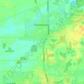
Nome: Mapa topográfico Huntertown, altitude, relevo.
Local: Huntertown, Allen County, Indiana, 46748, United States (41.19111 -85.21020 41.25262 -85.13373)
Altitude média: 259 m
Altitude mínima: 247 m
Altitude máxima: 275 m
Faça uma doação
Outros mapas topográficos
Clique em um mapa para visualizar sua topografia, sua altitude e seu relevo.
Fort Wayne
United States > Indiana > Allen County > Fort Wayne
The first settlement started in 1815. In 1819, the military garrison abandoned the fort and moved to Detroit. In 1822, a federal land office opened to sell land ceded by local Native Americans by the Treaty of St. Mary's in 1818. Platted in 1823 at the Ewing Tavern, the village became an important frontier…
Altitude média: 248 m
Faça uma doação