
Mapa topográfico Brusnica
Mapa interativo
Clique no mapa para exibir a altitude.
Sobre este mapa
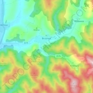
Nome: Mapa topográfico Brusnica, altitude, relevo.
Altitude média: 286 m
Altitude mínima: 172 m
Altitude máxima: 483 m
The municipality lies at an altitude of 199 metres and covers an area of 14.283 km². It has a population of about 415 people. The village has a significant Rusyn minority (32%) and smaller Romani minority (2%), along with the majority of Slovaks (65%).
Outros mapas topográficos
Clique em um mapa para visualizar sua topografia, sua altitude e seu relevo.
Stropkov
Slovakia > Region of Prešov > District of Stropkov
Stropkov, District of Stropkov, Region of Prešov, Eastern Slovakia, Slovakia
Altitude média: 265 m