
Faça uma doação
Mapa topográfico Riosucio
Clique no mapa para exibir a altitude.
Faça uma doação
Riosucio
The municipality is located in the west of the department. It is bounded by the municipality of Supía to the east, the municipality of Filadelfia to the south-east, the department of Risaralda to the south and west, and the department of Antioquia to the north. The total area of the municipality is 429.1 km2. The town of Riosucio lies at an altitude of 1783 meters above sea level, 91 km west of the departmental capital Manizales.
Faça uma doação
Sobre este mapa
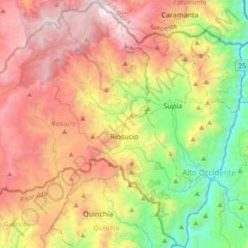
Nome: Mapa topográfico Riosucio, altitude, relevo.
Altitude média: 1.847 m
Altitude mínima: 639 m
Altitude máxima: 3.248 m
Faça uma doação
Outros mapas topográficos
Clique em um mapa para visualizar sua topografia, sua altitude e seu relevo.
Manizales
Manizales is the capital city of one of the smallest Colombian departments. The city is described as having an "abrupt topography", and lies on the Colombian Central Mountain Range (part of the longest continental mountain range, the Andes), with a great deal of ridgelines and steep slopes, which, combined…
Altitude média: 2.010 m
Faça uma doação