Geolocalizar

Mapa topográfico 黄埠

Mapa interativo

Clique no mapa para exibir a altitude.

Sobre este mapa

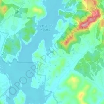
Nome: Mapa topográfico 黄埠, altitude, relevo.

Local: 黄埠, 常州市, 江苏省, 213000, 中国 (31.25057 119.39821 31.29057 119.43821)

Altitude média: 47 m

Altitude mínima: 13 m

Altitude máxima: 184 m

Outros mapas topográficos

Clique em um mapa para visualizar sua topografia, sua altitude e seu relevo.

茅山山脉

中国 > 江苏省 > 常州市

茅山山脉, 常州市, 江苏省, 213000, 中国

Altitude média: 36 m

三河村

中国 > 江苏省 > 常州市

三河村, 常州市, 江苏省, 213000, 中国

Altitude média: 5 m

滆湖

中国 > 江苏省 > 常州市

滆湖, 常州市, 江苏省, 213000, 中国

Altitude média: 4 m

祁家村

中国 > 江苏省 > 常州市

祁家村, 常州市, 江苏省, 213000, 中国

Altitude média: 8 m

太阳山

中国 > 江苏省 > 常州市

太阳山, 常州市, 江苏省, 213000, 中国

Altitude média: 119 m

中梅

中国 > 江苏省 > 常州市

中梅, 常州市, 江苏省, 213000, 中国

Altitude média: 9 m

前峰山

中国 > 江苏省 > 常州市

前峰山, 常州市, 江苏省, 213000, 中国

Altitude média: 62 m