
Faça uma doação
Mapa topográfico Westmont
Clique no mapa para exibir a altitude.
Faça uma doação
Sobre este mapa
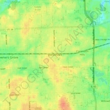
Nome: Mapa topográfico Westmont, altitude, relevo.
Local: Westmont, DuPage County, Illinois, 60559, United States (41.76483 -87.99423 41.82505 -87.94695)
Altitude média: 227 m
Altitude mínima: 206 m
Altitude máxima: 244 m
Faça uma doação
Outros mapas topográficos
Clique em um mapa para visualizar sua topografia, sua altitude e seu relevo.
Elmhurst
United States > Illinois > DuPage County
Due to local topography, the town has had a tendency to flood in the past after large rainfalls; the city is currently undertaking a large effort to mitigate future flooding.
Altitude média: 207 m
Elmhurst
United States > Illinois > DuPage County
Due to local topography, the town has had a tendency to flood in the past after large rainfalls; the city is currently undertaking a large effort to mitigate future flooding.
Altitude média: 207 m
Faça uma doação