
Mapa topográfico Kronwitt
Mapa interativo
Clique no mapa para exibir a altitude.
Sobre este mapa
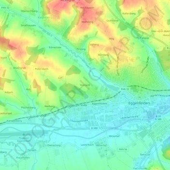
Nome: Mapa topográfico Kronwitt, altitude, relevo.
Altitude média: 428 m
Altitude mínima: 399 m
Altitude máxima: 480 m
Outros mapas topográficos
Clique em um mapa para visualizar sua topografia, sua altitude e seu relevo.
84307
Deutschland > Bayern > Landkreis Rottal-Inn > Eggenfelden
84307, Eggenfelden, Landkreis Rottal-Inn, Bayern, Deutschland
Altitude média: 425 m
Weinberg
Deutschland > Bayern > Landkreis Rottal-Inn > Eggenfelden
Weinberg, Eggenfelden, Landkreis Rottal-Inn, Bayern, 84307, Deutschland
Altitude média: 435 m