
Mapa topográfico Gopeshwar
Clique no mapa para exibir a altitude.
Gopeshwar
Gopeshwar is located at 30°25′N 79°20′E / 30.42°N 79.33°E / 30.42; 79.33. It has an average elevation of 1,450 m (4,760 ft). Gopeshwar is 8.4 km (5.2 mi) away from Chamoli which is located on the banks of Alaknanda river and along NH 58. Gopeshwar is able to captivate any visitor with its mystic charm and pristine beauty. There are multiple snow-capped hills and peaks visible from Gopeshwar.
Sobre este mapa
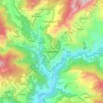
Nome: Mapa topográfico Gopeshwar, altitude, relevo.
Altitude média: 1.566 m
Altitude mínima: 895 m
Altitude máxima: 2.725 m
Outros mapas topográficos
Clique em um mapa para visualizar sua topografia, sua altitude e seu relevo.