
Mapa topográfico Hutt River
Mapa interativo
Clique no mapa para exibir a altitude.
Sobre este mapa
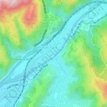
Nome: Mapa topográfico Hutt River, altitude, relevo.
Altitude média: 97 m
Altitude mínima: 16 m
Altitude máxima: 316 m
Outros mapas topográficos
Clique em um mapa para visualizar sua topografia, sua altitude e seu relevo.
Days Bay
New Zealand > Wellington > Lower Hutt
Days Bay, Lower Hutt, Wellington, 5013, New Zealand
Altitude média: 74 m
Somes Island
New Zealand > Wellington > Lower Hutt
Somes Island, Lower Hutt, Wellington, New Zealand
Altitude média: 1 m
Towai
New Zealand > Wellington > Lower Hutt
Towai, Lower Hutt, Lower Hutt City, Wellington, 5010, New Zealand
Altitude média: 123 m
Lake Kohangapiripiri
New Zealand > Wellington > Lower Hutt
Lake Kohangapiripiri, Kohangapiripiri Track, Lower Hutt, Lower Hutt City, Wellington, New Zealand
Altitude média: 32 m