
Mapa topográfico Minden
Mapa interativo
Clique no mapa para exibir a altitude.
Sobre este mapa
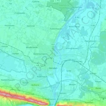
Nome: Mapa topográfico Minden, altitude, relevo.
Local: Minden, Kreis Minden-Lübbecke, North Rhine-Westphalia, Germany (52.24706 8.79206 52.36487 8.99831)
Altitude média: 60 m
Altitude mínima: 34 m
Altitude máxima: 262 m
The lowest part of the town is in the district of Leteln, at 40 metres (131 feet), while the highest part is in the district of Haddenhausen at 181 metres (594 feet). The altitude of the town is given officially as 42.2 metres (138.5 feet), based on the elevation of the town hall.