
Mapa topográfico Douglas County
Mapa interativo
Clique no mapa para exibir a altitude.
Sobre este mapa
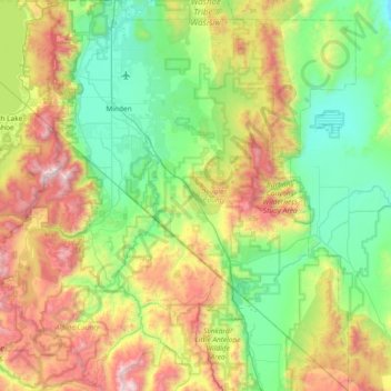
Nome: Mapa topográfico Douglas County, altitude, relevo.
Local: Douglas County, Nevada, United States of America (38.53617 -120.00343 39.11401 -119.31548)
Altitude média: 1.940 m
Altitude mínima: 1.345 m
Altitude máxima: 3.308 m
According to the U.S. Census Bureau, the county has an area of 738 square miles (1,910 km2), of which 710 square miles (1,800 km2) is land and 28 square miles (73 km2) (3.8%) is water. It is the second-smallest county in Nevada by area. The highest point is East Peak at 9,593 ft (2,924 m), while the most topographically prominent mountain is Mount Siegel.
Outros mapas topográficos
Clique em um mapa para visualizar sua topografia, sua altitude e seu relevo.
Death Valley
United States of America > Nevada
Death Valley, Beatty Wash Road, Nye County, Nevada, 92328, United States of America
Altitude média: 1.085 m