Geolocalizar

Mapa topográfico Junction Hill

Clique no mapa para exibir a altitude.

Sobre este mapa

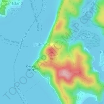
Nome: Mapa topográfico Junction Hill, altitude, relevo.

Local: Junction Hill, Central Coast Council, New South Wales, 2083, Australia (-33.55148 151.25254 -33.55138 151.25264)

Altitude média: 33 m

Altitude mínima: -3 m

Altitude máxima: 166 m

Outros mapas topográficos

Clique em um mapa para visualizar sua topografia, sua altitude e seu relevo.

Sydney

Australia > New South Wales

Sydney's topography is characterized by a diverse landscape that seamlessly blends coastal features with inland plateaus. The city is divided into two primary regions: the relatively flat Cumberland Plain to the south and west of Sydney Harbour, and the elevated Hornsby Plateau to the north. The Cumberland…

Altitude média: 51 m

Newcastle

Australia > New South Wales

Altitude média: 5 m

Sydney

Australia > New South Wales > Sydney

Altitude média: 23 m

Blue Mountains

Australia > New South Wales

A sandstone plateau dominated by a landscape of endless eucalyptus forests, the Blue Mountains are located at the top of a 470-million-year-old quartzite. In the Permian period, a shallow sea covered the region, when rivers brought shales, siltstones and mudstones. Then during the Mesozoic period, rivers…

Altitude média: 566 m

Goulburn

Australia > New South Wales

Owing to its elevation, Goulburn has an oceanic climate (Cfb) with warm summers and cool winters; with a high diurnal range. Its climate is variable much of the year, though generally dry with maximum temperatures ranging from 11.8 °C (53.2 °F) in July to 28.3 °C (82.9 °F) in January. Rainfall is…

Altitude média: 666 m

Armidale

Australia > New South Wales

Altitude média: 1.036 m

Crookwell

Australia > New South Wales

Crookwell is a small town located in the Southern Tablelands of New South Wales, Australia, in the Upper Lachlan Shire. At the 2016 census, Crookwell had a population of 2,641. The town is at a relatively high altitude of 887 metres and there are several snowfalls during the winter months. The nearest major…

Altitude média: 904 m

Darlinghurst

Australia > New South Wales > Sydney

Altitude média: 38 m

Berowra Heights

Australia > New South Wales

Altitude média: 125 m

Mudgee

Australia > New South Wales

Altitude média: 535 m

Eden

Australia > New South Wales

Altitude média: 55 m

Baulkham Hills

Australia > New South Wales

Altitude média: 93 m

Botany Bay

Australia > New South Wales > Sydney

Altitude média: 8 m

Robertson

Australia > New South Wales

Altitude média: 545 m

Coogee

Australia > New South Wales

Altitude média: 35 m

Granville

Australia > New South Wales

Altitude média: 17 m

South Windsor

Australia > New South Wales

Altitude média: 16 m

Bateau Bay

Australia > New South Wales

Altitude média: 16 m

Dunoon

Australia > New South Wales

Altitude média: 142 m

Banora Point

Australia > New South Wales

Altitude média: 17 m

Cudal

Australia > New South Wales

Altitude média: 466 m

Bunyah

Australia > New South Wales

Altitude média: 137 m

Repton

Australia > New South Wales

Altitude média: 18 m

Rylstone

Australia > New South Wales

Altitude média: 657 m

Milton

Australia > New South Wales

Altitude média: 33 m

Pearl Beach

Australia > New South Wales

Altitude média: 34 m

Tilba Tilba

Australia > New South Wales

Altitude média: 84 m

Ashby Heights

Australia > New South Wales

Altitude média: 45 m

Pillar Valley

Australia > New South Wales

Altitude média: 31 m

Grafton

Australia > New South Wales

Altitude média: 5 m

Bretti

Australia > New South Wales

Altitude média: 304 m

Bowral

Australia > New South Wales

Altitude média: 690 m

Sydney

Australia > New South Wales

Sydney's topography is characterized by a diverse landscape that seamlessly blends coastal features with inland plateaus. The city is divided into two primary regions: the relatively flat Cumberland Plain to the south and west of Sydney Harbour, and the elevated Hornsby Plateau to the north. The Cumberland…

Altitude média: 53 m

Oberon Council

Australia > New South Wales

Altitude média: 899 m

Byron Bay

Australia > New South Wales

Byron Bay, located in northeastern New South Wales, Australia, is characterized by diverse topography shaped by its geological history. The town is part of the erosion caldera of the ancient Tweed Volcano, which erupted approximately 23 million years ago, resulting in the rich volcanic soils that define the…

Altitude média: 7 m

Taree

Australia > New South Wales

Altitude média: 17 m

Goonellabah

Australia > New South Wales

Altitude média: 86 m

Prestons

Australia > New South Wales

Altitude média: 37 m

Walcha

Australia > New South Wales

Altitude média: 956 m

Castlereagh River

Australia > New South Wales

The Castlereagh rises 20 km west of Coonabarabran in the heart of the Warrumbungle mountains at an elevation of about 850 metres. From its commencement upstream in the mountains the river initially flows east through the town of Coonabarabran. It then arcs round south and southwesterly to the village of…

Altitude média: 240 m

The Lagoon

Australia > New South Wales

Altitude média: 762 m

Modanville

Australia > New South Wales

Altitude média: 118 m

Wingham

Australia > New South Wales

Altitude média: 47 m

Cabramurra

Australia > New South Wales

Altitude média: 1.226 m

Lake Keepit

Australia > New South Wales

Altitude média: 357 m

Urunga

Australia > New South Wales

Altitude média: 13 m

Penrith

Australia > New South Wales > Sydney > Penrith

Penrith is a city in New South Wales, Australia, located in Greater Western Sydney, 55 kilometres (31 mi) west of the Sydney central business district on the banks of the Nepean River, on the outskirts of the Cumberland Plain. Its elevation is 32 metres (105 ft).

Altitude média: 34 m

Redfern

Australia > New South Wales

Altitude média: 30 m

Meadowbank

Australia > New South Wales > Sydney

Altitude média: 19 m

Lilyfield

Australia > New South Wales > Sydney

Altitude média: 18 m

Mittagong

Australia > New South Wales

Altitude média: 672 m

Albion Park

Australia > New South Wales

Altitude média: 62 m

Blackheath

Australia > New South Wales

Blackheath (postcode: 2785) is an Australian town located near the highest point of the Blue Mountains, between Katoomba and Mount Victoria in New South Wales. The town's altitude is about 1,065 metres (3,494 ft) AHD  and it is located about 120 kilometres (75 mi) west north-west of Sydney, 11 kilometres…

Altitude média: 893 m

Woolgoolga

Australia > New South Wales

Altitude média: 29 m

Avalon Beach

Australia > New South Wales

Altitude média: 24 m

Cecil Hills

Australia > New South Wales

Altitude média: 77 m

Winmalee

Australia > New South Wales

Altitude média: 270 m

Bega

Australia > New South Wales

Altitude média: 44 m

Edmondson Park

Australia > New South Wales > Sydney

Altitude média: 56 m

Dural

Australia > New South Wales > Sydney

Altitude média: 157 m

Botany

Australia > New South Wales > Sydney

Altitude média: 6 m

Quakers Hill

Australia > New South Wales

Altitude média: 35 m

Hazelbrook

Australia > New South Wales

Hazelbrook is a town in New South Wales, Australia (Elevation: 675 metres) It is located 91 kilometres west of Sydney and 16 kilometres east of Katoomba in the Blue Mountains on the Great Western Highway.

Altitude média: 610 m

Richmond River

Australia > New South Wales

Altitude média: 257 m

Tintenbar

Australia > New South Wales

Altitude média: 49 m

Guthega

Australia > New South Wales

Altitude média: 1.743 m

Cargo

Australia > New South Wales

Altitude média: 539 m

Fairlight

Australia > New South Wales > Sydney

Altitude média: 23 m

Cooma

Australia > New South Wales

Altitude média: 869 m

Merriwa

Australia > New South Wales

Altitude média: 395 m