
Obrigado por apoiar este site ❤️
Faça uma doação
Faça uma doação
Mapa topográfico Decatur
Clique no mapa para exibir a altitude.
Obrigado por apoiar este site ❤️
Faça uma doação
Faça uma doação
Decatur
According to the United States Census Bureau, the city has a total area of 8.5 square miles (22 km2), all land. The highest point of elevation in the county is the courthouse site. As with ancient hill towns in Europe, the frontier settlement was developed on high ground for defensive purposes, so European settlers could see and ward off attacks or raids, in this case by Native Americans.
Obrigado por apoiar este site ❤️
Faça uma doação
Faça uma doação
Sobre este mapa
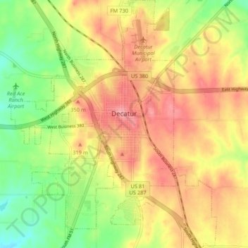
Nome: Mapa topográfico Decatur, altitude, relevo.
Local: Decatur, Wise County, Texas, 76234, United States (33.19772 -97.62301 33.26524 -97.55589)
Altitude média: 297 m
Altitude mínima: 245 m
Altitude máxima: 340 m
Obrigado por apoiar este site ❤️
Faça uma doação
Faça uma doação