
Faça uma doação
Mapa topográfico Maubourguet
Clique no mapa para exibir a altitude.
Faça uma doação
Maubourguet
The territory of Maubourguet extends over 22.04 km2; its elevation varies between 164 and 285 meters. The highest point of the commune is in the west, on the hills overlooking the plain of the Adour. The minimum elevation is at the level of the Adour when it leaves the territory in the north.
Faça uma doação
Sobre este mapa
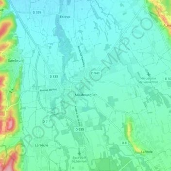
Nome: Mapa topográfico Maubourguet, altitude, relevo.
Altitude média: 186 m
Altitude mínima: 162 m
Altitude máxima: 298 m
Faça uma doação
Outros mapas topográficos
Clique em um mapa para visualizar sua topografia, sua altitude e seu relevo.
Hôtellerie du Cirque
France > Occitania > Hautes Pyrenees > Gavarnie-Gèdre > Gavarnie
Altitude média: 1.989 m
Faça uma doação
Cirque de Gavarnie
France > Occitania > Hautes Pyrenees > Gavarnie-Gèdre > Gavarnie
Altitude média: 2.364 m
Lac de Gaube
France > Occitania > Hautes Pyrenees > Cauterets
The lake is situated in an altitude of 1725 m, an egg-shaped form stretching itself along a north–south axis in the valley of Gaube. This steep-sided valley is located at the foot of the Vignemale (3298M). The lake is surrounded by the peak Mayouret (2688 m) to the east, the big Peak of the Paloumères (2720…
Altitude média: 2.079 m
Faça uma doação
Vue sur Cascades et Pont d'Espagne
France > Occitania > Hautes Pyrenees > Cauterets
Altitude média: 1.827 m
Pierrefitte-Nestalas
France > Occitania > Hautes Pyrenees > Pierrefitte-Nestalas > Pierrefitte-Nestalas
Altitude média: 712 m
Faça uma doação
Cirque de Gavarnie
France > Occitania > Hautes Pyrenees > Gavarnie-Gèdre > Gavarnie
Altitude média: 2.364 m
Faça uma doação
Faça uma doação