
Obrigado por apoiar este site ❤️
Faça uma doação
Faça uma doação
Mapa topográfico Ihuatzio
Clique no mapa para exibir a altitude.
Obrigado por apoiar este site ❤️
Faça uma doação
Faça uma doação
Ihuatzio
Ihuatzio is located on the southeast of the Lake Pátzcuaro, about 8 kilometers southwest of the town center of Tzintzuntzan. Its average elevation is 2,052 meters above the sea level.
Obrigado por apoiar este site ❤️
Faça uma doação
Faça uma doação
Sobre este mapa
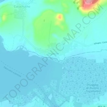
Nome: Mapa topográfico Ihuatzio, altitude, relevo.
Local: Ihuatzio, Tzintzuntzan, Michoacán, 61609, Mexico (19.54578 -101.63842 19.58578 -101.59842)
Altitude média: 2.052 m
Altitude mínima: 2.035 m
Altitude máxima: 2.175 m
Obrigado por apoiar este site ❤️
Faça uma doação
Faça uma doação