
Mapa topográfico Hohensaas
Mapa interativo
Clique no mapa para exibir a altitude.
Sobre este mapa
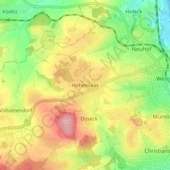
Nome: Mapa topográfico Hohensaas, altitude, relevo.
Local: Hohensaas, Hof, Bayern, 95030, Deutschland (50.29356 11.85657 50.33356 11.89657)
Altitude média: 544 m
Altitude mínima: 469 m
Altitude máxima: 627 m
Outros mapas topográficos
Clique em um mapa para visualizar sua topografia, sua altitude e seu relevo.
Rosenbühl
Deutschland > Bayern > Hof > Osseck
Rosenbühl, Osseck, Hof, Bayern, 95030, Deutschland
Altitude média: 539 m
Unterkotzau
Deutschland > Bayern > Hof > Unterkotzau
Unterkotzau, Hof, Bayern, 95030, Deutschland
Altitude média: 509 m
Osseck
Deutschland > Bayern > Hof > Osseck
Osseck, Hof, Bayern, 95030, Deutschland
Altitude média: 551 m
Alsenberg
Deutschland > Bayern > Hof > Alsenberg
Alsenberg, Hof, Bayern, 95028, Deutschland
Altitude média: 510 m